This history is a copy of the booklet produced by Stephen Freer around 1972.

Where we have copies of the photographs in the booklet these have been used otherwise they are copies from the original booklet.
Introduction to Rotherby

The Village and Parish of Rotherby is situated nine and a half miles northeast of Leicester, and five and a half miles southwest of Melton Mowbray. The village can be seen to be resting on the eastern ridge of the very beautiful Wreake valley.
Rotherby lies on the left-hand side of the road running from Leicester to Melton, where the view across the Wreake valley is most pleasant.
It is a quiet and peaceful village, with approximately one hundred and forty inhabitants. There is little through traffic, as it is on a loop road, and one does not go through it to get anywhere, nor is there a public house. The village does, however, have a little shop-cum-post Office. Until about three years ago it used to have a village school, but the beauty of the village is centred on its striking thirteenth century church.
Although Rotherby appears small and quiet, over the past eleven or so centuries, it has seen its, fair share of events, and has quite an interesting history.
The early history of the village of Rotherby and Parish
Settlement in this area being in east Leicestershire was mostly kept to the high ground. The evidence of this is the Iron Age fort at Burrough Hill and the flint implements found at Tilton-on-the Hill. Both of these places are on particularly high ground which was easily defended and farmed. One can almost certainly say that Rotherby is not pre-Roman, although the Fosse Road is only about four miles to the west of the village.
The nearby village of Thrussington is probably the earliest village in the area. As the ending ‘ton’ suggests, the village is of Anglo-Saxon foundation, so possibly Saxons might have used the land around Rotherby for hunting or fighting.
The River Wreake which runs through the valley gets its name from the Anglo-Saxon word ‘Wrecan’ which means ‘revenge’. It is thought by historians that the valley was probably the site of at least one, if not more, Saxon/Viking confrontations.
The route of the Saxon and Viking invasion is shown below.

The Vikings would have over-run any Saxon settlement and then have erected a fortified village. The area around Rotherby was heavily settled by the Vikings. The place name ending of ‘by’ is Danish for town, and in just the local area, such villages as Hoby, Brooksby, Rearsby, Frisby and Gaddesby will be noticed.
The name Rotherby has over the years had many different variations of spelling and meaning. The first mention of Rotherby is found in the Domesday Book in 1068, and appeared as Redebi. Later variations included Rederbia and Reytherby. Doctor W. G. Hoskins says the origin of the name is Old Norman, a personal name Rethaer – farm of the read hair, the same derivation being true for the neighbouring village of Rearsby. In a history of Rotherby church written in 1882 by the Reverend J. A. Donovan, he stated that the name came from Riderbye meaning town of the Rider, the old name for the Wreake. The most common variation of Rotherby is from the Danish word ‘rude! or ‘rede’ meaning Cross. The village was probably known as the town of the Cross.
The word cross suggests an early village church, and this church was either replaced or rebuilt by Roger de Brett circa 1200 A.D. If there was an earlier church, it would almost certainly have been a timber building.

The Brett family who derived their name from the word Brito, meaning Briton, would possibly have come over with the Norman Duke in the eleventh century. The Bretts would have been granted the Knight’s fee of Rotherby from William the Conqueror and it was his task to control and look after the Parish.
The Manor House, which was demolished in the 1930’s, had been rebuilt on the site where the Bretts had built the ancient Manor House of about the twelfth century. This house in Nichol’s Survey of the County in the 1790’s was called the ‘Hall House’.
Nichols says:
“The Hall House being an old building yet standing at the east end of the church yard was formerly inhabited by the Bretts, sometime Lords of this town”
This ancient Anglo-Norman family continued to flourish in Rotherby and in 1394 Roger de Brett granted a considerable part of Rotherby to the Priors of Chaucombe in Northamptonshire.
In these times, Rotherby, thanks to the Bretts, must have been quite a religious village. The Church, for a couple of hundred years, was linked with the Priory and Convent at Launde in the east of the County. In fact, in 1535 a pension of 6s 8d was paid to Launde Abbey.
These are some of the early extracts of the history of Rotherby but, in fact, the earliest mention of the village was found in the Domesday Book of 1086. This nationwide survey carried out by William the Conqueror, stated that Rotherby was to have contained almost three plough lands, three ox gangs, and quite a few carucates. The carucates being a measurement of land from which it is being measured against the amount of land an Ox gang can plough in a year.
In fact, the Earl of Chester was said to have held six carucates and, also in this period, Earl Hugh Lupus was said to have held a number of carucates and two acres of meadow.
During this time Rotherby certainly seemed to have its fair share of influential people in the village.
The village at this time might even have been fortified in order to keep out invaders. This though is only speculation and it seems more probable that only the Manor House was fortified. The peasants houses would have been scattered around the Manor and village life would have revolved around the family of Brett. The Bretts had a long existence in the village, but they finally sold the Manor to Sir Thomas Hartopp in 1654, and they then disappear from the village records.
During the period between 1300 to about 1600 there is still very little factual evidence of Rotherby. This is mainly because the majority of people could not read or write and those who could were not particularly interested in keeping records. In fact the first actual census of Rotherby was in 1801.
The population in the 14th and 15th centuries would probably have been around the same as that of today but the village would have seemed larger as the houses were smaller and more were needed.
The houses would probably have been made of wood. There would have been no shortage of food in the village with the fertile soil round about. During this period the village peasants would farm for the Lord of the Manor.
As well as produce off the land, fish from the nearby river would have been a very popular item of diet. On all sides of the village, there were, and are still, many freshwater streams, so that drinking water would have been no problem. During this time the Church would have played a great part in the villagers life and would have been the social high centre of the village.
After the Norman Conquest of this County, the land was taken over by Lords who were granted areas of ground to look after and farm. These were known as Knight’s Fees. In Rotherby it is believed that the land was originally granted to the Brett family.
This family would have kept the land for their own living and rented the untaken land to peasants in the village who farmed the land. The peasants would be obliged to give a percentage of the crop yield to their Lord. These peasants worked on their own land and spent the remainder of their time working on the Manor for the Lord.
The land which the peasants farmed was divided into three large fields. In Rotherby these open fields were known as High, Middle and Nether. Two of the fields would probably have contained Barley, Wheat, or Oats. The third field would have been fallow. The fields would be divided into strips, and each strip would be shared between the peasants.
The drainage method of Ridge and Furrow was popular in Rotherby at this time, and in fact there is one field in particular, known as the Park Close, where signs of Ridge and Furrow method are still visible. This field is a large field between Rotherby and Brooksby.
The peasants favoured the method of grazing animals as this was particularly suitable where the soil was poor, but the Lord of the Manor, who was still a Brett, found this method less profitable. The Lords did their utmost to clear the peasants off their land, and when the Black Death came in 1348 many peasants died. This meant that the Lords were able to pursue the profitable method of enclosure. For some reason though, Rotherby, unlike neighbouring village Brooksby, was enclosed later in 1674, whereas Brooksby was enclosed in 1374. This might suggest that Rotherby did not suffer so severely as Brooksby in the Black Death, but this cannot be proven.
The enclosure meant that the large fields were fenced into smaller ones, but this often proved too expensive for the peasants, and many had to sell their land to the Lord of the Manor. Later in the eighteenth century peasants, who lost their work, moved into the towns where industry was growing. Enclosure brought prosperity to the rich and hardship to the poor.
Farmers turned to arable farming especially in times when the textile industry was growing and there was a keen demand for wool. Fewer workers were needed, and this caused rural depopulation, which led to seven villages in the Wreake Valley becoming deserted – Brooksby being one of these.

General history of Rotherby throughout the middle ages and through until today
Up until 1471 I cannot find any mention of the population of the village. In this year a window tax was taken, and twelve houses were recoded as being rated in this tax. Again in 1564 it is stated that thirteen families lived in the village. The population would have been around one hundred as the families were larger in those days and the larger houses would have a number of servants in them.
The Parish Registers date back from 1561 and an entry for a Baptism in the following year is probably the most famous entry of all time. This was of George Villiers, who later became the father of the great Duke of Buckingham, favourite of James I and Charles I. This family lived at Brooksby Hall for many centuries.
During this period the village church made two important collections: the first in 1556 for the sum of £5 14s 2d for suffering Swiss Protestants in Piedmont, and later in 1655 £5 11s 6d was collected for the same cause.
In 1621 living in the village was a certain Sir Alexander Cave. In this year he received pardon for stealing three pieces of gold and all offences of adultery and fornication committed by him.
In fact, the seventeenth century seems to have been quite an eventful period. It is around this time when people began to take an interest in making records, and the foundation of Rotherby’s history based on fact, can be found here.
During the Cromwellian period, this county, as was the whole country, faced with Civil War, and Rotherby was no exception. In 1642 Thomas Rawson was granted the rectorship of Hoby, another neighbouring village lying on the other side of the Wreake. In the following year the living was sequestrated by Parliament and he was forced to leave. It does not appear that he was given much choice and soon afterwards a Rector named Smith was appointed. Seeing this, Mrs. Rawson and her family showed a spirit of independence by refusing Smith’s possession of the parsonage.
Mr. Smith then allied with what was described as a ‘Party of Horse’ from Leicester, proceeded to turn the Rawson family out of their house, and into the churchyard. They were thought to have used very hard and persuasive methods. It is presumed that the ‘Party of Horse’ were Roundheads as the rural areas were previously Royalist strongholds.
Mrs. Rawson camped with her children in Hoby church, and they lived in the porch. Mr. Needham the curate of Rotherby then gave the family the shelter of his parsonage, until he in turn had to flee.
Mrs. Rawson and her numerous family were turned out of Hoby parsonage a second time, and lay in Rotherby churchyard. However, at length they were admitted within the doors and lived in the belfry where blankets were used to separate them from the congregation. It is thought that they existed for a considerable time like this, but later the family came on to the parish, and were then apprenticed to lace makers and other trades. Mrs. Rawson later died, but after the troubles her husband returned to Hoby in 1660.
The ancient parish records, with entries of the following, shows what was thought of these turbulent and troubled times. The entries are as follows:
” 1643, 1644, 1645. Bellum: Bellum! Interruption, persecution. “
” 1645 Sequestration by John Musson yeoman, and John Yates Taylor“
It was in this period of history when the Bretts family finally sold the ancient Manor House. This powerful and proud family had reigned as Lords of the Manor for probably over five centuries. There seems to be some slight confusion around this period though, because Sir Alexander Cave in some old records was stated as living in the Manor House during the 1620’s. The Manor House, being under the ownership of the Bretts, was probably tenanted out to Cave. The Bretts were reported to have sold the Manor in 1654 to Sir Thomas Hartopp. It is interesting to note how many influential people were beginning to use Rotherby as their village residence, and this continued until the 1920’s when the large houses fell into disrepair.
Interesting to consider is that the Bretts sold the Manor in the middle of Parliamentary unrest i.e. Civil War, as well as the sale of the Manor twenty years previously on the completion of the enclosure of Rotherby.
Up until the early eighteenth century we cannot be sure whether the site of the village had stayed the same throughout the Middle Ages. On an early map of this county in 1500, there is the suggestion that the village was possibly sited more to the side of Brooksby, the Manor being the north most house. This could have been true. If one examines the large field in between Rotherby and Brooksby called the Park Close, there is considerable earth work along the eastern side of the road, but any explanation for this would be hard to find.
It is in the seventeenth century when Rotherby first becomes aware of the Seaman family. The Reverend Lawrence Seaman, founder of the family, owned a considerable amount of land in Rotherby, and was a native of Leicester. By his eloquence he attracted the notice of Archbishop Laude, who appointed him to the living of All Hallows in London in 1642. He took the side of Parliament in the Civil War and lost his living. The family became considerably powerful and wealthy and continued to be involved with Rotherby for about two hundred years, contributing one of the two charities in the village.
The building of the village school was financed by Mr. W. C. P. Seaman in 1848, and largely owned by themselves, and they must have owned the majority of the acreage in Rotherby. The Seamans still inhabited the Manor in 1800, but it seems unlikely that they spent much time in the village. When the village church was restored in 1882, a collection was raised, for which Mrs. Pierce Seaman generously gave £100, though it seems unlikely that they were residents in the village at this time. In the church there are several tablets which testify to the virtues of this once great family.
It is during the eighteenth century that houses were first built of brick. The first brick house in the area was built in Syston in 1685. Prior to that date the houses were built of mud or wood, which might explain the reason for the site of the village moving.
In the present day village, there are probably fifteen or so eighteenth century brick houses, the prime example being the seven cottages off the Main Street known as the Row. These houses date from around the 1740’s. They were probably built as houses for farm labourers once the Manor Farm was built, and the houses are still rented from this farm. The majority of the houses and people of this time were linked in one way or another with the Manor, and this trend continued until the closure of the large houses in the 1920’8 and 1930’s.
Around the 1720’s on the north-eastern side of the village, was built what was known as Rotherby Hall. This was built due to the great demand for country property in this area due to the popularity of hunting. Rotherby, as we shall discuss later, was no exception.
The Hall was built of brick by the Seaman family who purchased the estate from the Hartopps. The grounds attached to the Hall consisted of four acres. During the next two centuries this house became both a very lively and beautiful homestead. Many important visitors stayed there as they did in the other large houses in Rotherby, and these visitors often had hunting interests. It is worthy of note that the price at which this property was first purchased in 1740 was £4,000.
In 1922 the estate was purchased by the Cooperative Wholesale Society, and in 1928 or thereabouts, the Hall was demolished.
During the eighteenth century many of the houses were built of our own Rotherby brick. At this time a brickyard was in existence on a thick clay belt just over the Gaddesby side of the main Melton to Leicester road. This yard would have employed a few men from the village, and its situation was ideal for transport.
The village was now beginning to assume it’s present appearance. The houses, although often replaced, stood in similar positions to those of today. The houses known as the Row seem to have been re-built sometime during their long history, and these houses, as with others in the village, have ironstone and other stones in their lower portions.
Apart from the village brickyard, people in the eighteenth century were either employed in the large houses, or to do such work as that of a blacksmith, butcher, wheelwright, carrier, or farmer. It seems that nearly everyone who lived in the village, was also employed there.
It was around this time that various corn mills were built on the banks of the River Wreake, and there was one between Rotherby and Hoby. This would no doubt have provided employment for a number of men, as would the transport developments of the canals and railways which will be discussed later.
The large houses were also places of employment for a large number of men and women, their tasks varying to include gardeners, farmers, coach drivers, stud grooms, laundry workers, cleaners, cooks and stable boys. As the eighteenth century progressed, we find Rotherby becoming centred around these three or four large houses in the village. The centre of attraction was that it was an ideal site for hunting in the winter season. As the county gentry became wealthy, due possibly to the growth of the hosiery industry, we find them taking a great interest in hunting, and this area around Melton Mowbray has been traditional hunting ground for many a year. The wealthy people who were interested in the sport would move out of the towns and purchase a residence in the country, and for this Rotherby was a very good example. The village became laced with rich hunting folk, and the landowners were not allowed to grow too many crops, and were forced to concentrate on pastoral farming, favoured because it meant that hunting could take place on their land. Even today there are many more fields of pasture than those of crops, but the hunting tradition seems to be on the wane.
In these times, however, hunting was the main reason why Rotherby was generally rather a wealthy village. The poor folk were given coal and food from the landowners, and much money was injected into the village. The pastime of hunting grew more and more, and by the turn of the nineteenth century the village saw many wealthy landowners move into it. Apart from this there were also many travellers who stayed just for the winter months. These travellers included many British and American millionaires, and many different businessmen. In fact, in the early twentieth century, the Duke of Windsor came often as did Sir Malcolm Campbell (the superspeed driver of the Blue Bird, and in the early eighteen hundreds the Queen of Spain stayed in Rotherby.
At the turn of the century the leading landowners in Rotherby were Dutton Seaman, Mr. Hudson, Mr. Blower, Mr. Mansfield, and Mr. Boultbee. Mr. Dutton Seamen was one of the long lines of the family previously mentioned, the Mr. Boultbee was probably Joseph Boultbee a wealthy philanthropist, and Mr. Mansfield was a banker and previously a draper. Mr. Mansfield after releasing the original partner, Mr. Oliver, joined forces with Mr. Boultbee, and this same Mr. Mansfield was also Lord Mayor of Leicester for a period. Joseph Boultbee was related to the famous Leicestershire painter John Boultbee, who often painted for Robert Bakewell of Dishley, Nr. Loughborough, and George III.
With the hunting season being in the winter, the summer was in complete contrast with the village partially empty. The wealthy landowners would either be on vacation somewhere, or possibly renewing their business interests.
At this time the village consisted of two large houses, the Hall and the Manor. Later after 1823 the parish was made a united benefice with Hoby, but the rectory was still lived in by a church curate. Later in the 1880’s the Rectory was owned by the Reverend Bahri, and in the church there is a brass plaque testifying to him. This was one of the first church unions in the area and has existed ever since. In fact, this century has seen Rotherby join the benefice of Hoby, Ragdale and Brooksby, although this has caused a certain amount of resentment among the villagers.
At the bottom of the Row on the left is a house known as Rotherby Cottage or Manor Cottage. In the nineteenth century this house was used as a ‘Public House’ known as the ‘Wheatsheaf’ This public house was possibly opened about 1770 and closed about a hundred years later. It would possibly have been, as the word suggests, a public house where a normal room with a few extra tables and chairs would be used by a few villagers for a place in which to drink, whilst domestic life went on normally in the rest of the house. To the rear of the premises are a number of stables which suggests that the house would have had residents staying there. This house would again have been particularly busy during the winter.


The returns made to The House of Commons in the year ended Easter 1786 in answer to an enquiry respecting the charitable donations of this Parish.

Transport in the area and growth of the village until the present day
From the eighteenth century onwards, Rotherby was particularly well positioned concerning transport. The River Wreake was made navigable in the 1790’s and carried much traffic. The village was also well positioned for road transport, as the main Leicester to Melton toll road ran along the edge of the village. It was possibly true to say that this road would be in quite good condition for the time, because of the wealthy residents of Rotherby and the adjoining villages. The condition of these toll roads depended on the class of area and the amount of money used for repairs. In fact, a parishioner can remember a relative telling him of the time when Queen Victoria travelled along this road en route for Belvoir Castle, so this road must have been of creditable condition. It was also a popular routeway for people travelling by coach to Leicester Races then held on Victoria Park.
The condition however, of the side roads in the area was unlikely to have been very good, especially in winter. In 1846 the Syston to Peterborough Railway was opened, and this followed for the most part, a straightened version of the River Wreake from Syston to Melton.
As was the case all over England, the railways adversely affected the canals, and in 1877 the Leicester canal was closed. The railways resulted in quicker, cheaper transport.
Looking through the records, on Rotherby, there is no mention of the affect, if any, of the completion of the Syston to Peterborough Railway on the village and district. The railway was opened in 1846 but obviously work had taken place on it for many years previously. There would have been many workers needed to build this railroad, and they would have spent some of their time in the village.
After this period no doubt the village shoemakers, bakers, inn keepers and village storekeepers were the poorer, once the heavy work of the line was completed. It was possibly only about twenty years later when the village public house was closed, which underlines the fact that trade was reduced once the railway was completed. As earlier stated, the canal traffic was greatly reduced by the coming of the railway, and in 1877 the canal was closed.
The Wreake Navigation was begun in 1797 and ran for 14.75 miles. This heavy work on the building of the canal possibly proved prosperous for the village. The cost of coal in the area after the navigation was opened was said to have been reduced from 18d a cwt to 9d a cwt. This would certainly have benefited the villagers. In 1838 the waterway was said to have carried 40,000 tons, and traffic was rapidly increasing, but after the coming of the railway, the tonnage in 1848 had been cut to 30,000 tons, and later in 1868 these had dropped yet again to 1,000 tons. Over these last twenty years the receipts had dropped from £1,400 to £327, a considerable drop. Nine years later it was considered unprofitable to continue.
Even today there are plain signs of the transport in the area, Along the river banks there are many wooden stakes, which would have been used to secure the barges, and on the bed of the river there are still signs of coal.
Nowadays the river is quite shallow, but in those days it must have been considerably deeper. Along the river on the way to Frisby is the site of the old corn mill. This was probably built during the heyday of the canal. The weir, lock and actual mill are still visible, but the actual mill is not. The mill would have employed a number of men from the village, and when closed, it would have been a great loss to the village.
At this time though, many of the villagers would still be employed by the owners of the large houses and the Manor, Hall Lodge and Cottage would probably have housed about a third of the village.
The rewards for work in these large houses was probably minimal, but work was hard to come by in a purely agricultural area such as this. This fact is even more clear when we consider that the leading hunting areas were certainly pasture strongholds, and therefore fewer farm hands were needed, and this after enclosure meant rural unemployment. Many of the unemployed either found jobs with the leading landowners, or moved into the industrial areas i.e. Leicester, Melton Mowbray, Syston, Loughborough, and the Sileby and Mountsorrel area. The improvement and development of transport facilities made it possible for people to move into these urban areas.
Looking back again at the details of transport in the village, it is likely that many of the villagers would have owned their own cart, and the wealthier folk would also own a horse to pull the cart.
During the nineteenth century, a horse and cart as a means of transport was so popular, that Rotherby had a wheelwright and a carpenter and blacksmith all working in the village. These three employers would all be concerned with this form of transport.
The enclosure of land meant possible hardship for cottagers, tenants, and general working-class villagers, but for the wealthy landowners it brought more wealth and more land especially after the poor sold up their land to them. This wealth in the hands of the large landowners also benefitted the poor population of the village. Rotherby was particularly well off by the latter half of the nineteenth century due to the increased popularity of hunting. The injection of money into the village meant that houses were well kept, trees were planted throughout the village, and these have done much to enhance its picturesque appearance as can be seen in the photographs taken during the early twentieth century. Today the trees along the road going out to Frisby and Gaddesby were planted by these landowners. The villagers were given coal and small luxuries such as oranges, sweets, and chocolates by these wealthy inhabitants.
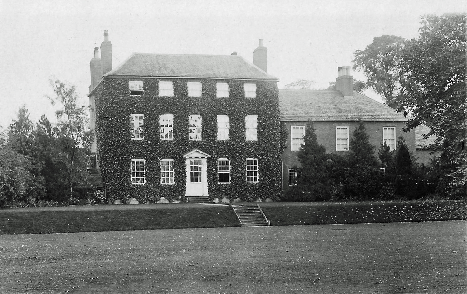
During the late eighteen hundreds, Colonel Goodchild at the Manor and Miss Hames at the Hall helped to organise and provide the capital to restore the church. In fact £2,000 was raised. The church at this time was said to be falling into grave disrepair (the details of the restoration will be given later). The Goodchilds moved into the Manor after Mr. Thomas Johnson lived there. In 1856 Mr. Johnson bought the Manor from Mrs. Wilson, and later in the 1870’s he repaired and modernised the building. The house was then in the form that is represented in the photograph of the Manor taken in the 1920’s.
Previously the Manor was a wooden/stone building, but later, after the alterations it was re-constructed of brick. After the Goodchild’s the Manor was owned by Mr. and Mrs. Horncastle, and its final owners were Mr. John and Lady Teresa Cross.
Many of these people, and such residents at the Hall as the Hames family were wealthy due to being great industrialists. The Hames and Lockwood families were hosiery manufacturers during the late eighteen and early nineteen hundreds.
By the turn of the twentieth century Rotherby was still a very popular hunting village, and the agriculture was still pretty much the same being mostly pastural. By this time though, the flood. plain of the Wreake had been completely drained, and could be used for agriculture as well.
There were numerous stables in the village during this period and these were at: – Rotherby Hall, The Manor, the Cottage (formerly the Wheatsheaf Public House), Rotherby Lodge and after 1900 the ‘Stables’ . Today much of this evidence is still standing, although no horses are now kept in the village.
During the early nineteen hundreds many villagers were employed by leading farmer David Wood of the Manor Farm. His employees were concentrated around the houses known as The Row later to be bought by the new owners of Manor Farm the Rippins. Other jobs included work on the railways, signal man and booking clerk. The large houses employed gardeners, cleaners, cooks, chauffeurs, grooms and other general workers.
As the years progressed the First World War came upon the country, but it would appear that it did not affect life in the village too much. It is quite surprising actually to discover the number of men in the village who did not go to the war. They were possibly needed on the farms to help stimulate agricultural production.
During the war however, the Allfrey family left the village, and the Hall was unable to be sold. The house stood empty for a number of years and as the need for workers dis-appeared the men and women turned to local industries to find employment. The Holwell Iron works were popular, and other industries in Leicester were within easy reach thanks to the Railway.
The Manor was still occupied until about 1927 by Mr. John and Lady Teresa Cross, but after this date the family moved to Asfordby Hall. Afterwards the Manor stood empty until 1933 when it too was pulled down, and the site remained empty until the late 1940’s.
The Hall and the Manor were pulled down after they had fallen into dis-repair due to the general financial depression in the country after the war. As a result of the demolition of the two largest houses, much of the land around the village was also up for sale. Also in 1933, Mr David Wood the owner of Manor Farm died, and as a result his land and property were put up for sale. The Old Rectory was sold in the 1920’s and was re-named Rotherby Grange.
All these points explain why in 1933 and 1945 there was large sale of the Rotherby Estate by Auction.
By the 1940’s the large landowners of the village were the Co-operative Wholesale Society, the Leicester City Corporation and a few local farmers. The land on which the Hall originally stood, changed hands from the Co-op to the City Corporation. The land was used for nurseries and gardens with a considerable number of glass houses in the grounds. The actual date of the sale by the Co-operative Society to the Corporation was in 1941.
For the villagers it must have been very disheartening to see the two most beautiful houses in the village pulled down. The local farmers now tended to buy up some of the land owned by the Co-op and Leicester Corporation. It was during this era of the Second World War that agriculture in Rotherby really began to thrive. With the war time restrictions on imports into this country, all of Britain’s farmers were needed to step up production, and this meant that the farmers were not able to go to the war. This applied in Rotherby, and the few villagers who did go to the war, mostly worked in factories.
The war had little effect on the village apart from general items such as the black-out regulations, food rationing and the housing of evacuees. A village Home Guard unit was formed and was stationed in the grounds of the old Hall, now the Nurseries owned by the Leicester Corporation. The unit was about ten members strong. The village Air Raid shelter was on the hill by the stud groom’s old cottage, on the way to Frisby. The village was never bombed and was generally quiet. There were a few exceptions though, especially when a German fighter plane was shot down in the large field between Rotherby and Brooksby. A few German bombers caused alarm whilst flying over the village attempting to bomb Holwell Iron Works, then concerned with making arsenal for the war.
American Air Force personnel were stationed at the neighbouring village of Gaddesby, whilst Brooksby Hall was taken over by the Red Cross and used as a Convalescent Home for war casualties.

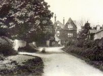
Photographs of the village in the 1920s


Taken from “The Church Magazine for the Parishes in the Deanery of Goscote II. Edition July 1911
“A Rotherby Coronation Day opened with Holy Communion at the Church at 8 a.m., followed by a Childrens’ procession to the church for the second service at 9.30 a.m. During the morning a cricket match Married v Single pleasantly filled in the time until dinner which commenced for children at 12.15 p.m. and for the adults at 1.00 p.m.
“A programme of sports way carried out in the afternoon at 3 o’clock. Tea was served at 4 o’clock for the children and for the adults at 5 o’clock.
After the meal the sports were resumed, and the distribution of prizes took place immediately after the conclusion of them. A string band played at intervals during the day. After the supper the committee had provided an excellent entertainment consisting of cinematograph, A comedian and a conjuror. By kind permission of Capt. and Mrs. Allfrey the motor house was used as a dining hall and was prettily decorated.
Extract from Kell’s Directory for the year 1888

Excerpts of Rotherby around the year 1900
MANOR FARM.
A large farm known as “Manor Farm’ built around 1879. On the same site an ancient farm stood. Farm owned by the Woods, and later by the Rippins.
BACKWATERS.
The original course of the river was altered by the railways. The river was straightened to prevent the need for two bridges over it.
BROOKSBY STATION.
There is a now disused station and it was originally built around 1850. It was very popular with villagers until road transport considerably improved. This station was more elegant than other local stations, possibly due to the numerous large houses in Rotherby and Brooksby.
THE STABLES.
Built around 1900 with several horse boxes. The lawns were used for drying clothes from the Manor, and also an area for walking the horses.
ORCHARD HOUSE.
Owned now by Mrs. Spurr is one of the village’s oldest houses built in 1725. It was previously a laundry to the large houses in the village.
THE VILLAGE SHOP AND POST OFFICE.
Built around 1740’s but did not become a post office until about 1870, and later on became a shop as well. The house next door had previously been a lending library for such things as books. There was also stable room at the shop.
THE ROW.
Built around 1740, a row of seven cottages, previously for farm workers. Built of brick with iron stone in some of their lower brick work. The gardens at the back of the cottages were used for keeping pigs.
NANNY COOPER’S COTTAGE.
Up until the late 1880’s a well known village character known as Nanny Cooper lived in a mud walled thatched cottage, and was the owner of one of the beauty spots of the village.
RECTORY.
Probably built around the 1780’s, but seems likely that an ancient building stood there before. It is a large old house with spacious grounds. It was sold in 1920 and was later called Rotherby Grange.


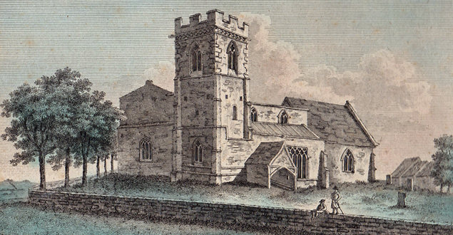
The village church
The central figure of the village is surely the ancient Church, situated in the middle of the village next to the old Manor House.
The date of the present Church is estimated to be around the thirteenth century. As mentioned earlier the ancient name of the village came from the Danish word ‘Rood’ meaning “Cross’, which could have signified an early village church or pagan worship ground. The Danes were enthusiastic church builders.
It seems very likely that there was a Danish church, and this would probably have stood on the same site as the present one. The material used for the early church would have been wood, but it was the Anglo-Norman family of Brett who built something like the present-day church.
The actual date of the building is probably around 1220, a supposition supported by the fact that the first know vicar of the church was Hombart in 1220.
The first stone building would only slightly have resembled the present day one. It seems likely that it would have consisted of a chancel, an altar and an area reserved for public worship. The entrance would almost certainly have closely resembled the present day one, on the side of the village. The building materials used were mostly limestone, but later, possibly in the fourteenth century, the perpendicular styled tower was built of a crumbly sandstone material. As mentioned earlier, some villagers maintain the belief that the blocks of stone used were from the valley below the village, but this seems unlikely.
The Brett family of this time were certainly devout church goers, because in 1394 Roger de Brett granted a considerable part of Rotherby to the Priors of Chaucombe in Northamptonshire. The patrons of the early church were from the Priory and Convent of Launde, also in the county of Leicestershire, and now known as Launde Abbey.
The fourteenth century seemed to have been the time of re-building and enlarging the church. Evidence for this includes a blocked west window, now replaced in a higher position. The roof also seems to have been raised during this re-building period. Another interesting feature of this time is the arch which leads up into the Chancel and altar. On the north wall by the arch there seems to be a scar in the wall and on the altar side there is a mass of what looks like spare masonry. This would seem to suggest that the archway was possibly moved slightly in an easterly direction.
The church now has two aisles although only the chancel is used as one today. The south aisle was possibly used by worshippers in the older building, but today it is not used. A very ancient piscinae remains, and this is used for the priest to keep his Communion wine and bread in, and illustrates an unusual dog-tooth mould, a very uncommon feature after the thirteenth century, and a beautiful example of early English architecture.
In the main aisle a fourteenth century piscinae is still in use, and it seems probable that the early example was used particularly in the time of the early construction work of the re-building.
The majority of the church’s structure still standing seems to be mainly of this fourteenth century re-building period. The building material of the church seems certain to be considerably older than this period, and likely to have been re-used.
The Church has many handsome mediaeval windows, but a number of them were repaired and altered in the later restoration of the church in 1882.
It was not until the fourteenth century that the perpendicular south-west tower was added. This appears to have been an afterthought as it was built inside the south aisle. A good explanation for this is the lack of space west of the church. The tower is in three stages, and is embattled, and does not have a spire.
It was during these times that the north facing door-way was built, but this is now blocked, possibly about two hundred years ago. The doorway was probably used as an entrance door for the families living in the nearby Manor House. The inside walls of the church would have been covered in white plaster, featuring quite a few drawings or sketches.
The three church bells were added around the 1600’s. The first bell which has the inscription ‘Ave Maria, gratia plena, Dominus . tecum’ is considerably earlier that the other two. No actual date can be found on it but it is believed to be pre-reformation 1533. The second bell was added in 1597 and has inscribed on it:
‘Come and pray, 1597’
The third and final bell has inscribed on it:
‘A.B.C.D.E.F. 1611′
The bells when rung say traditionally ‘Come and pray’.
In 1600 a stone was placed in the church testifying to the virtues of Robert Brett. It says:
‘Hic facet Robertus Brett, miles’.
The Brett family disappear from the records around the 1659’s.

Nichol’s survey of the County carried out around the 1790’s mentions an ancient font, two fragments of painted glass, many floor monuments, but these and especially the stone testifying to Robert Brett have somehow disappeared. It is believed they disappeared in the restoration of 1882.
In John Thorsby’s book ‘Leicestershire View’ he states:
“The church has a very capacious old font almoft in the form of a tub”
The restoration of churches during this period was especially common throughout the Wreake Valley. The cost of Rotherby’s restoration was around £2,000 and the wealthy landowners and relatives of past landowners such as the Hames and Burnabys, helped the village to reach this sum.

In 1882 a Fair was held in the Corn Exchange at Leicester, and the proceeds went towards the Rotherby Church Funds, the sum of £160 being raised. Other large donations were made by the rector of the parish Mr. G. Beresford, and Colonel Goodchild churchwarden, Miss Hames and Mrs. Pierce Seaman.
The church was described as having fallen into grave decay, and the plans were prepared by W. Millican Esg., Architect of Leicester, and the work included a new vestry, porch and six new windows. The plaster was removed from the walls, and a new pulpit, south and Communion rails were made from the oak timber of the old roof. A new roof was also erected. The walls of the church were repaired, and the old church gate was replaced. Seating was installed throughout the church in oak, and finally an organ was also installed,
During this restoration period a number of items in the church were placed in memory of certain people. In 1882 the ancient font was replaced with one which seemed to be similar to a deep pudding basin and had four supporting columns of Purbeck stone. The font bears the inscription:
“Suffer little children to come unto me’
Also marked on the font are the words: “Presented by Mrs.Goodchild”
In an Arch between the chancel and the vestry a brass plaque was placed and a tombstone of an early Rector can be found under a modern oak canopy decorated with leaves and roses. The brass plaque says:
“This ancient tombstone CVC A.D. 1230 was restored and adorned A.D. 1911 to the Glory of God’s House, and in memory of her husband Joseph Bahri, late curate of this parish, by Anna Bahri his Widow”
In 1912, the Reverend Beresford moved the organ from the Chancel to it’s present position, and he also restored the Chancel by voering it with richly painted panels depicting figures of various saints. A note on one of the panels reads:
“The restoration and adornment of the Chancel were effected in 1911-12. The Reverend A. A. Beresford”
The rebuilding of the church was definitely necessary, but it was carried out harshly, and many items of historical value were lost. As earlier mentioned, such items as the font, floor monuments, and fragments of painted glass disappeared. It is believed that when the floor was tiled in 1882, the tiles covered many stones which marked internal tombs.
In the year 1998 the church clock was installed, and is still in perfect working order today.
The church of the present day is not very different from the one at the turn of this century. There are still quite a few wall tablets in honour of past villagers such as the Seamen, Burnaby and Hartopp families.
The church has now been fitted with electricity and the aisles are covered with a glorious red carpet. A new gate has been erected in memory of the late Mr. J. Rippin. The villagers are justly proud of their church and many visitors come to see their treasure. Thanks to certain villagers, the running of the church is communal, as members of the local community participate in such tasks as flower arranging, cleaning, bell ringing and grass cutting.

A list of some of Rotherby’s early rectors
| Hombart | 1220 | Priory and convent of Launde |
| William Prowedfole | 1534 | Priory and convent of Launde |
| William Thorpe | 1562 | Priory and convent of Launde |
| Richard Smith | 1607 | Buried 1610 |
| Samuel Hill | 1610 | |
| Francis Needham | 1631 | |
| Francis Chamberlain | 1640 | |
| Francis Needham | 1642 | |
| Gilbert Woodward | 1660 | |
| Edward Smith | 1667 | Buried 1682 |
| John Reading | 1683 | |
| John Steele | 1691 | Died 1715 |
| Thomas Pocklington | 1797 | |
| Paul Belcher | 1768 | |
| Henry Woodcock | ||
| Paul Belcher | 1775 |
Rotherby School
The birth of schooling in Rotherby was due mainly to two generous charities left to the village.
Mrs. Catherine Gregory in her will dated 1723, left the village a piece of land above the present school which would be let to a local farmer. The rent from this land would be used to help to buy the children of the village a book every Christmas, a Bible on leaving the school, and would also help the children once they had left the school by helping with their further education, for example the paying of apprenticeship fees. Village children can still receive these benefits and the field is still owned and let by the Church, and is thus named “The Charity Field”.
In the eighteen and early nineteen hundreds before the building of the village school, there was a house at the top of the ‘Row’ in which one of the rooms was let for the teaching of the village youngsters. This would possibly have been what is now known as a “Dame School”.

The village school was built in 1848, which at the time was comparatively early, and it was primarily a charity school for the poor children. The wealthy children of the village would almost certainly have been sent away to boarding school. Those villagers who could afford it would pay a small amount to attend school. In 1863 the school mistress was paid the sum of £10 per annum.
After Forstor’s Act of 1870 the school was turned into an elementary school for mixed pupils. In the 1880’s Miss Brown was the school mistress, and such subjects as needlework, scripture and knitting were taught. Miss Brown wore a frilled dress, and a part of her task was to take her children to church every Sunday, and those who did not turn up at church, would be severely caned the next day.
The school was built to take up to forty pupils, and apart from the Rotherby children, children from nearby Brooksby were also taught there. In 1901 the average attendance was twenty-three with the population of the village standing at one hundred and eleven souls. At that time the percentage of children to the population was much higher than in 1970.
As the twentieth century progressed the school was divided into two classrooms, and over the years, and indeed even until the school was closed in 1974, the children have always been proud of their spacious playing area at the back of the building. In the 1950’s new changing rooms and an improved toilet block were built. During the 1960’s the authorities helped to provide the children with several amenities, such as a television set, a telephone, modern teaching equipment, and adequate kitchen facilities. The premises had also been fitted with an oil-fired central heating system, and employed a caretaker to look after it.

With the closure of Hoby school in the late 1960’s, the children from that village were forced to travel to Rotherby. The numbers at Rotherby school figured from thirty to thirty five, which was a considerable increase on that of ten to fifteen years previously. Two teachers were now employed, one to teach the infants ranging from the five to seven year olds, and the other to teach the junior children with ages ranging from eight to eleven years. In the 1970’s the cutbacks imposed by the local authority caused a decision to build a large new primary school at Frisby for the children of the surrounding area, and Rotherby school followed the fate of Hoby and was also closed. The building was sold in 1976, and has now been converted into a house, although the appearance of the building has not been allowed to be altered.
The large houses of Rotherby that have now disappeared

The Hall which was situated on the Frisby side of the village was an eighteenth century brick house built by the Seamen family. The estate was purchased from the Hartopp family who owned a great percentage of Rotherby around 1700.
The Seamen family still owned the Hall in 1877, though for many years the building had been tenanted by Mr. Joseph Flames, whose family lived here until the turn of the nineteen hundreds.
The Hall consisted of many large rooms, and bedrooms. Also a large Ball-room was a prominent feature in which many cheerful dances were held. The Hall consisted of about four acres of land. The house had a driveway and a large rose bed in front of it. Still standing to this present day are the stables and a couple of houses which are now empty but were formerly used for workers at the Hall. A fishpond stood in front of the hall, but this has now become rather overgrown. Another pond also stood at the rear of the Hall. Across the road in the opposite field was the village cricket ground which dated back to the mid eighteenth century. The whole area in front of the Hall had been beautifully landscaped, with every tree position planned to the nearest foot.
The Hall had many distinguished guests staying in it from time to time, and even after 1908 under the then ownership of Captain N. St Clair Allfrey, many parties were still held there, either inside or in the grounds in the form of either garden parties or band concerts.
From the beginning of the first World War the Hall stood empty and by 1922, the estate was purchased by the Co-operative Wholesale Society. The Hall was later demolished in 1928, and the Leicester Corporation took over the property and turned the site into a garden nursery. Over the years these nurseries have provided employment and created interest among the villagers, and they are open to the general public at certain times of the year.

The Manor House was by far the oldest building in the village apart from the church. The early building was probably built of either stone or wood, and was obviously a large and gracious building, and might even have been defended during the Norman era.
By 1870 the Manor House was in rather a dilapidated state, and it was at this time that the Johnson family rebuilt the house in brick and stone with a slate roof,
The estate was of considerable extent, and included a large house, stables, garages, lawns, large gardens and a tennis court.
The building consisted of many large rooms and was entered through a glazed Porch. The rooms included a Drawing Room, Dining Room, Domestic’s Room, Morning Room, Kitchen, Scullery, and a number of bedrooms.
The grounds consisted of nicely shaded and well matured trees and included tennis and other lawns. A section of the garden was segregated for fruit trees.
The stabling was situated in front of the house, near the village street, and consisted of twelve loose boxes, three stalls, and a large garage. Also in the grounds were a cowshed, two pigsties, store shed, fodder lofts and Groom’s quarters.
Recently with building taking place on the site, ancient cellars have been discovered, but they were filled in, possibly to be re-discovered in two or three hundred years time.
A summary of the past and an idea of what the future holds in store for Rotherby
Before the 1930’s horses and hunting had been more than just a spectacular place in the lives of the villages, it was their livelihood.
Now in the village there is neither Hall nor Manor: demolition contractors took the large houses away. The stud grooms and stable boys of yesterday and those people who might have found employment attached in some way to the large houses and the hunt etc. now either farm the land, work in Rotherby nurseries, or the majority of workers find employment in the local factories at either old Dalby, Holwell Iron Works, Pedigree Petfoods or Rearsby Components.
The future is difficult to assess, but it seems unlikely that there will ever be any major development in the area. This is mainly due to the local land being mainly of “Green Belt”. This means that the land must not be built on or defaced in anyway whatsoever.
The modern age of gas power has yet to reach the village, although pipelines run alongside the nearby main Leicester to Melton Mowbray road. The inadequacy of the sewerage system has also stopped any great development in the village, although this was rectified late in the 1960s, with a cost of a quarter of a million pounds.
In the future, possibly one of the main factors to affect the village will be the nearby coalmine, expected to be at Asfordby. Over one thousand workers are expected to be employed there, and this might give rise to the need to house some of these workers in local villages. This though is only speculation, and only time will tell the fortune of the village.